Abstract
In an attempt to fight the rising incidence of obesity and promote healthy lifestyles, the City of Pasadena has proposed developing urban planning projects to promote healthy lifestyles. One of the projects is to place “Park and Walk” lots throughout the city. Several criteria were identified as being essential to this project. A Geospatial Analysis was performed in order to select the Parcel that met all the criteria necessary to identify the ideal Park and Walk lot location. The ideal location for the Park and Walk lot located in the City of Pasadena is a parcel identified by the Assessor’s Identification Number (AIN) 5735006034. The analysis suggests that if the final parcel was found not to be suitable for some other reason, the runner up would be functionally equivalent. This also implies that there is potential room for expansion of the park and ride facility if it becomes necessary. Opportunities exist for other urban planning projects with a spatial component that might be further explored to promote healthy lifestyles.
Introduction
In an attempt to fight the rising incidence of obesity and promote healthy lifestyles, the City of Pasadena has proposed developing urban planning projects to promote healthy lifestyles. One of the projects is to place “Park and Walk” lots throughout the city. The idea is to provide free parking in these lots for the first 90 minutes to provide an incentive for commuters to walk to multiple businesses and points of interest in the city, rather than drive to each destination independently.
Several criteria were identified as being essential to this project. The Park & Walk lots must be located within the City of Pasadena or the City of South Pasadena. The lots need to have a Zoning Code of C4, CD-5 AD-2, or RS. In order to accommodate anticipated demand, the lots must have an area greater than 3,000 square meters. The lot selected has to be within 100 meters of either Fair Oaks Avenue or Colorado Boulevard and within 300 meters of an existing bike path. The final parcel selection must meet all the previously listed criteria and have the greatest number of businesses and points of interest within a 200-meter radius.
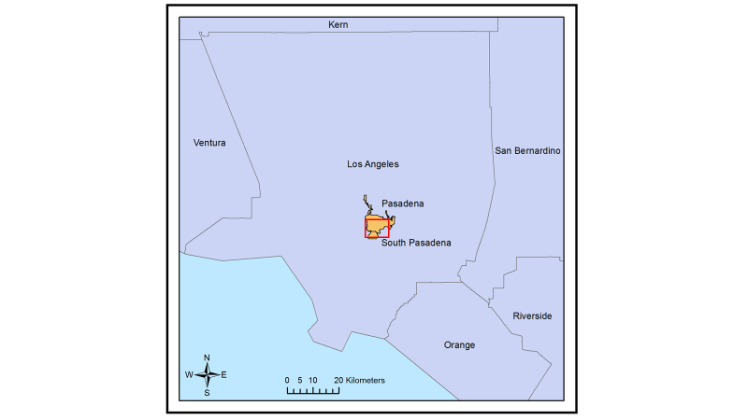
Figure 1: Location of Pasadena and South Pasadena, California, in Los Angeles County.
Methods
A Geospatial Analysis was performed in order to select the Parcel that met all the criteria necessary to identify the ideal Park and Walk lot location. Shapefiles containing city boundaries for Los Angeles County, zoning codes at the parcel level, roads, and points of interest were downloaded from the Los Angeles County GIS Data Portal website (http://egis3.lacounty.gov/dataportal/). A bike path layer was downloaded from the Los Angeles County Metropolitan Transit Authority’s Metro.net website (http://developer.metro.net/introduction/bikeways-data/download-bikeways-data/). The Bike Path data was in KML format, and had to be converted first into a file geodatabase, and then into a shapefile and projected into the same projected coordinate system as the data from the Los Angeles County. After a quality assurance and quality control process was completed, then the process of narrowing down potential sites could begin.
The city boundaries for the City of Pasadena or the City of South Pasadena were used to clip all the other shapefiles to restrict all analysis to within the boundaries of the target area. The new Zoning and Parcels shapefile was used to calculate the area of all the parcels and those with an area greater than 3000 m2 were selected and a new shapefile created. Of the parcels over 3000 m2, those with zoning codes of C4, CD-5 AD-2, or RS were then selected and a new shapefile created. From the roads shapefile, Fair Oaks Avenue (including North or South Fair Oaks) and Colorado Boulevard (including East or West Colorado) were then selected and a new shapefile created as a result. Parcels from the most recent shapefile within 100 meters of the selected roads were selected and exported as a shapefile. From the new shapefile, parcels within 300 meters of a Bike Path were selected and yet another shapefile created of the few remaining parcels. A 200-meter buffer was created around each of the parcels in the new shapefile. and a count field added to the points of interest shapefile and each point assigned a value of 1. the buffered parcels were joined with the Points of Interest that fell within the buffers and the Sum Function used to tally the count fields of the points of interest that lay within each buffer. This count was used to determine the parcel that had the greatest number of points of interest within 200 meters, and thus the parcel that met all the criteria identified for the location of the Park and Walk lot.
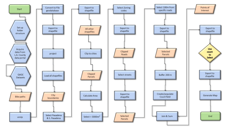
Figure 2: A flowchart outlining the steps taken to identify the Park and Walk lot location in the City of Pasadena
Results
The ideal location for the Park and Walk lot is in the City of Pasadena. It is a parcel Measuring 3221 m2 Located on East Green Street, one block from Colorado Boulevard and one block from the nearest bike path. It has 47 points of interest within 200 meters, although one of them, a brokerage, appears to be located on the parcel itself. The Parcel is zoned CD-5 AD-2 and is Identified by the Assessor’s Identification Number (AIN) 5735006034.
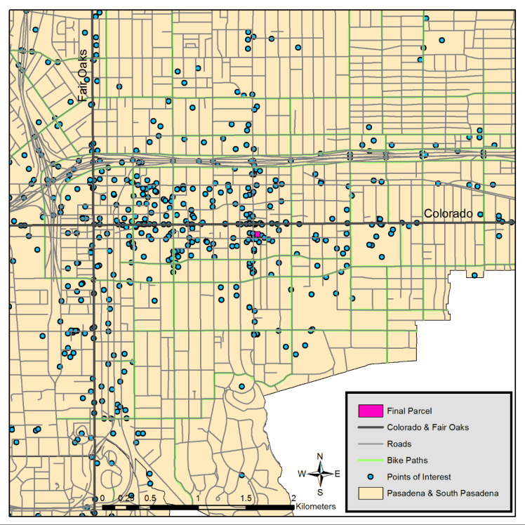
Figure 3: Location of the final parcel selected for the Park and Walk lot. Projected Coordinate System is NAD 1983 State Plane California V FIPS 0405.
Conclusion
The resulting parcel was one of 4 that met all of the criteria other than having the greatest number of points of interest within 200 meters. This parcel was within 200 meters of 47 points of interest, another parcel nearby met all the same criteria and was within 200 meters of 45 points of interest. All of the final four were grouped tightly in a cluster, which suggests that if the final parcel was found not to be suitable for some other reason, the next runner up would be functionally equivalent. This also implies that there is potential room for expansion of the park and ride facility, should that become necessary in the future, but if an additional location was desired to create another Park and Walk lot somewhere else in Pasadena, other criteria would need to be used. Other criteria that might be considered for future Park and Walk lots include access to public transit and areas with known parking and congestion issues.
This type of analysis is useful for many other urban planning applications, and some urban planning projects with a spatial component might be further explored to promote healthy lifestyles. One such type of application would be network analysis to plan for safe bicycle and pedestrian passage. Another type of application that has a spatial component and would promote healthy lifestyles would be an analysis similar to this one that would have the goal of locating a recreation facility or gym in an area underserved by such amenities.
Acknowledgements
Data Sources include the Los Angeles County GIS Data Portal website http://egis3.lacounty.gov/dataportal/ for Shapefiles containing city boundaries for Los Angeles County, zoning codes at the parcel level, roads, and points of interest. the Los Angeles County Metropolitan Transit Authority’s Metro.net website http://developer.metro.net/introduction/bikeways-data/download-bikeways-data/ for the bike path KML and the FracTrackerAlliance http://www.arcgis.com/home/item.html?id=2f227372477d4cddadc0cd0b002ec657 for the California Counties shapefile used in the locator map
